Article
Rivière Richelieu
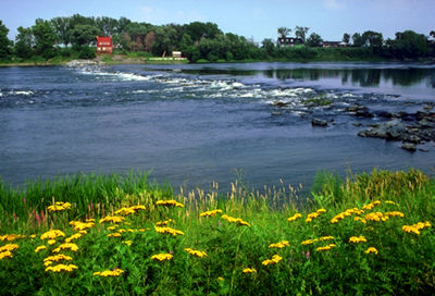
The Richelieu River has played a prominent role in the historical development of Québec. Originally inhabited by Iroquois, Huron and Algonquin, Samuel de CHAMPLAIN navigated its waters shortly after his arrival in 1608.
Signing up enhances your TCE experience with the ability to save items to your personal reading list, and access the interactive map.
Create AccountArticle
The Richelieu River has played a prominent role in the historical development of Québec. Originally inhabited by Iroquois, Huron and Algonquin, Samuel de CHAMPLAIN navigated its waters shortly after his arrival in 1608.
"https://d2ttikhf7xbzbs.cloudfront.net/media/media/eb8d4d81-eea3-4fe3-b07d-149f6170ebbf.jpg" // resources/views/front/categories/view.blade.phphttps://d2ttikhf7xbzbs.cloudfront.net/media/media/eb8d4d81-eea3-4fe3-b07d-149f6170ebbf.jpg
Article
Rivière Romaine, 496 km long with a 14 350 km2 basin, rises (elev 760 m) in the Québec-Labrador lacustrine plateau, 45 km southwest of the CHURCHILL RIVER, and forms part of the Québec-Labrador boundary north of the 52nd parallel.
"https://development.thecanadianencyclopedia.ca/images/tce_placeholder.jpg?v=e9dca980c9bdb3aa11e832e7ea94f5d9" // resources/views/front/categories/view.blade.phphttps://development.thecanadianencyclopedia.ca/images/tce_placeholder.jpg?v=e9dca980c9bdb3aa11e832e7ea94f5d9

Article
The Rouge River is a tributary of the Ottawa River. Its source is Lac de la Fougère, in the northeast part of Rouge-Matawin Wildlife Reserve in Québec.
"https://d2ttikhf7xbzbs.cloudfront.net/media/media/6953ea93-69d2-40dd-a80d-f44f0be8c655.JPG" // resources/views/front/categories/view.blade.phphttps://d2ttikhf7xbzbs.cloudfront.net/media/media/6953ea93-69d2-40dd-a80d-f44f0be8c655.JPG

Article
Rivière Saint-François, 280 km long, drainage basin 10 230 km2, is located in southern Québec.
"https://development.thecanadianencyclopedia.ca/images/tce_placeholder.jpg?v=e9dca980c9bdb3aa11e832e7ea94f5d9" // resources/views/front/categories/view.blade.phphttps://development.thecanadianencyclopedia.ca/images/tce_placeholder.jpg?v=e9dca980c9bdb3aa11e832e7ea94f5d9
Article
Rivière Saint-Maurice, 563 km long, rises upstream from Réservoir Gouin, 200 km west of Lac Saint-Jean, Québec. It drains a basin of 43 300 km2. After its confluence with Rivière Manouane, it feeds Réservoir Blanc and then takes in the Vermillon, Trenche, Croche, Mattawin and Mékinac rivers.
"https://d2ttikhf7xbzbs.cloudfront.net/media/media/26ddf9e4-78b9-4850-b1ab-94971048ce2e.jpg" // resources/views/front/categories/view.blade.phphttps://d2ttikhf7xbzbs.cloudfront.net/media/media/26ddf9e4-78b9-4850-b1ab-94971048ce2e.jpg

Article
Canada's first highways were the rivers and lakes used by Indigenous peoples, travelling by canoe in summer and following the frozen waterways in winter. (See also Birchbark Canoe; Dugout Canoe.) The water network was so practical that explorers, settlers and soldiers followed the example of the Indigenous peoples. (See also Coureurs des bois; Voyageurs.) To a greater extent than most other countries, Canada depends for its social, economic and political life on efficient communication and transportation. (See also Economy; Politics.)
"https://d2ttikhf7xbzbs.cloudfront.net/media/media/a2f5cb61-ed14-46ed-9cea-f9bdc1ee18bd.jpg" // resources/views/front/categories/view.blade.phphttps://d2ttikhf7xbzbs.cloudfront.net/media/media/a2f5cb61-ed14-46ed-9cea-f9bdc1ee18bd.jpg
Article
The Robert McLaughlin Gallery (formerly the Art Gallery of Oshawa) was established by a group of artists and citizens of Oshawa, Ont, in February 1967.
"https://d2ttikhf7xbzbs.cloudfront.net/media/media/360eeafe-8a5c-47a2-b469-9a1795ebcf9e.jpg" // resources/views/front/categories/view.blade.phphttps://d2ttikhf7xbzbs.cloudfront.net/media/media/360eeafe-8a5c-47a2-b469-9a1795ebcf9e.jpg

Article
A navigation centre for the lake and an internationally renowned summer resort until the early 20th century, Roberval also had a few sawmills. The Ursulines built their provincial convent here in 1882. A hospital was added in 1918.
"https://development.thecanadianencyclopedia.ca/images/tce_placeholder.jpg?v=e9dca980c9bdb3aa11e832e7ea94f5d9" // resources/views/front/categories/view.blade.phphttps://development.thecanadianencyclopedia.ca/images/tce_placeholder.jpg?v=e9dca980c9bdb3aa11e832e7ea94f5d9
Article
Roblin, Manitoba, incorporated as a village in 1913 and as a town in 1963, population 1774 (2011c), 1672 (2006c). The Town of Roblin is situated on Goose Lake 400 km northwest of Winnipeg near the Manitoba-Saskatchewan border.
"https://d2ttikhf7xbzbs.cloudfront.net/media/media/4bdc8f29-c5bc-4346-8b69-eacb517ce926.jpg" // resources/views/front/categories/view.blade.phphttps://d2ttikhf7xbzbs.cloudfront.net/media/media/4bdc8f29-c5bc-4346-8b69-eacb517ce926.jpg

Article
Rockwood, Manitoba, incorporated as a rural municipality in 1880, population 7964 (2011c), 7692 (2006c). The Rural Municipality of Rockwood is located north of Winnipeg; it includes the communities of Stony Mountain, Grosse Isle, Argyle, Balmoral, Gunton and Komarno.
"https://development.thecanadianencyclopedia.ca/images/tce_placeholder.jpg?v=e9dca980c9bdb3aa11e832e7ea94f5d9" // resources/views/front/categories/view.blade.phphttps://development.thecanadianencyclopedia.ca/images/tce_placeholder.jpg?v=e9dca980c9bdb3aa11e832e7ea94f5d9
Article
Rocky Mountain House, Alberta, incorporated as a town in 1939, population 6,635 (2016 census), 6,933 (2011 census). The town of Rocky Mountain House is located on the North Saskatchewan River, 81 km west of Red Deer. It is near the site of the North West Company’s fur trade post of the same name.
"https://d2ttikhf7xbzbs.cloudfront.net/media/new_article_images/RockyMountainHouse/c007376.jpg" // resources/views/front/categories/view.blade.phphttps://d2ttikhf7xbzbs.cloudfront.net/media/new_article_images/RockyMountainHouse/c007376.jpg

Article
Rocky Mountain House National Historic Site, near Rocky Mountain House, Alberta, commemorates a series of fur-trade posts built between 1799 and 1864 by the North West Co and the Hudson's Bay Co (HBC) near the junction of the North Saskatchewan and Clearwater rivers.
"https://development.thecanadianencyclopedia.ca/images/tce_placeholder.jpg?v=e9dca980c9bdb3aa11e832e7ea94f5d9" // resources/views/front/categories/view.blade.phphttps://development.thecanadianencyclopedia.ca/images/tce_placeholder.jpg?v=e9dca980c9bdb3aa11e832e7ea94f5d9
Article
The Rocky Mountain Trench is a long and deep valley extending approximately 1,500 km from the Bitterroot Valley in northwest Montana through British Columbia to the Liard Plain just south of the Yukon Territory. Its predominantly flat floor is 3–20 km wide and ranges in elevation between 600 m and 1,000 m above sea level. With walls made of sedimentary, volcanic and igneous rock, the Trench is sometimes referred to as the “Valley of a Thousand Peaks” because of the towering mountain ranges on either side: the Rocky Mountains to the east and the Columbia, Omineca and Cassiar mountains to the west. Humans have relied on the rich resources provided by this distinctive landscape from pre-colonial times to the present.
"https://d2ttikhf7xbzbs.cloudfront.net/media/media/061fe992-a3bf-45bc-906d-216d1bef45c7.jpg" // resources/views/front/categories/view.blade.phphttps://d2ttikhf7xbzbs.cloudfront.net/media/media/061fe992-a3bf-45bc-906d-216d1bef45c7.jpg

Article
Castlelike mountain resorts built on the rail line at Banff and Lake Louise have become all-season recreation centres for Banff National Park's (established 1885) many alpine attractions, which attract 4.5 million visitors annually.
"https://d2ttikhf7xbzbs.cloudfront.net/media/media/ebac2147-4f0e-4324-844b-afdbfd364b52.jpg" // resources/views/front/categories/view.blade.phphttps://d2ttikhf7xbzbs.cloudfront.net/media/media/ebac2147-4f0e-4324-844b-afdbfd364b52.jpg

Article
During the summer of 1885 the railway was constructed over the pass at great expense. Over 6.4 km of snowsheds (31) were built to protect trains, trackage and workmen from AVALANCHES (the area receives up to 15 m of snow each winter).
"https://d2ttikhf7xbzbs.cloudfront.net/media/media/4a73903a-ec12-49d4-86cb-2a9cbd3c3f23.jpg" // resources/views/front/categories/view.blade.phphttps://d2ttikhf7xbzbs.cloudfront.net/media/media/4a73903a-ec12-49d4-86cb-2a9cbd3c3f23.jpg
