Article
Charlo
Charlo, NB, incorporated as a village in 1966, population 1324 (2011c), 1386 (2006c). The Village of Charlo is located eight kilometres southeast of Dalhousie on CHALEUR BAY, in the civil parish of Colborne.
Signing up enhances your TCE experience with the ability to save items to your personal reading list, and access the interactive map.
Create AccountArticle
Charlo, NB, incorporated as a village in 1966, population 1324 (2011c), 1386 (2006c). The Village of Charlo is located eight kilometres southeast of Dalhousie on CHALEUR BAY, in the civil parish of Colborne.
"https://development.thecanadianencyclopedia.ca/images/tce_placeholder.jpg?v=e9dca980c9bdb3aa11e832e7ea94f5d9" // resources/views/front/categories/view.blade.phphttps://development.thecanadianencyclopedia.ca/images/tce_placeholder.jpg?v=e9dca980c9bdb3aa11e832e7ea94f5d9

Article
Chester, NS, incorporated as a village in 1963, population 1529 (2011c), 1496 (2006c). The Village of Chester, 72 km west of HALIFAX, is situated on a point of land bounded by a harbour, at the north end of Mahone Bay.
"https://development.thecanadianencyclopedia.ca/images/tce_placeholder.jpg?v=e9dca980c9bdb3aa11e832e7ea94f5d9" // resources/views/front/categories/view.blade.phphttps://development.thecanadianencyclopedia.ca/images/tce_placeholder.jpg?v=e9dca980c9bdb3aa11e832e7ea94f5d9
Article
Chesterfield Inlet, Nunavut, incorporated as a hamlet in 1980, population 313 (2011c), 332 (2006c). The Hamlet of Chesterfield Inlet is located in a bay on the south shore of CHESTERFIELD INLET on the west side of Hudson Bay, 101 km northeast of RANKIN INLET.
"https://development.thecanadianencyclopedia.ca/images/tce_placeholder.jpg?v=e9dca980c9bdb3aa11e832e7ea94f5d9" // resources/views/front/categories/view.blade.phphttps://development.thecanadianencyclopedia.ca/images/tce_placeholder.jpg?v=e9dca980c9bdb3aa11e832e7ea94f5d9
Article
Chéticamp, NS, Unincorporated Place. Chéticamp is located on the Gulf of St Lawrence, 48 km northeast of Inverness.
"https://d2ttikhf7xbzbs.cloudfront.net/media/media/01aec0ff-e8a3-4d3b-ac01-3207ccdb4336.jpg" // resources/views/front/categories/view.blade.phphttps://d2ttikhf7xbzbs.cloudfront.net/media/media/01aec0ff-e8a3-4d3b-ac01-3207ccdb4336.jpg

Article
Clyde River, Nunavut, incorporated as a hamlet in 1978, population 934 (2011c), 820 (2006c). The Hamlet of Clyde River is located on the west shore of Patricia Bay on the east coast of BAFFIN ISLAND, 750 km north of IQALUIT.
"https://d2ttikhf7xbzbs.cloudfront.net/media/media/9974cb6b-fdb8-4408-a0cb-ddcadd23aa9d.jpg" // resources/views/front/categories/view.blade.phphttps://d2ttikhf7xbzbs.cloudfront.net/media/media/9974cb6b-fdb8-4408-a0cb-ddcadd23aa9d.jpg

Article
Coral Harbour, Nunavut, incorporated as a hamlet in 1972, population 891 (2016 census), 834 (2011 census). The hamlet of Coral Harbour is located at the head of South Bay on Southampton Island in Hudson Bay, 715 km southeast of Iqaluit. The name Coral Harbour is descriptive and refers to the fossilized coral in its harbour. The Inuit’s traditional name for the site and the island, Salliq, is also descriptive and means “flat island.”
"https://development.thecanadianencyclopedia.ca/images/tce_placeholder.jpg?v=e9dca980c9bdb3aa11e832e7ea94f5d9" // resources/views/front/categories/view.blade.phphttps://development.thecanadianencyclopedia.ca/images/tce_placeholder.jpg?v=e9dca980c9bdb3aa11e832e7ea94f5d9
Article
Craigellachie, BC, is a small community located at the west entrance to Eagle Pass. Craigellachie was the place where Donald Smith drove the symbolic "last spike" in a ceremony marking the completion of the Canadian Pacific Railway.
"https://d2ttikhf7xbzbs.cloudfront.net/media/media/62923069-c687-482d-b465-8d1c007b323c.jpg" // resources/views/front/categories/view.blade.phphttps://d2ttikhf7xbzbs.cloudfront.net/media/media/62923069-c687-482d-b465-8d1c007b323c.jpg

Article
Cumberland, BC, incorporated as a village in 1958, population 3398 (2011c), 2762 (2006c). The Village of Cumberland is located on the east coast of Vancouver Island about 14 km south of COURTENAY and 93 km northwest of NANAIMO.
"https://development.thecanadianencyclopedia.ca/images/tce_placeholder.jpg?v=e9dca980c9bdb3aa11e832e7ea94f5d9" // resources/views/front/categories/view.blade.phphttps://development.thecanadianencyclopedia.ca/images/tce_placeholder.jpg?v=e9dca980c9bdb3aa11e832e7ea94f5d9
Article
Déline, NWT, incorporated as a charter community in 1993, population 472 (2011c), 525 (2006c). The Charter Community of Déline is located on the shores of GREAT BEAR LAKE, 544 air km northwest of Yellowknife.
"https://d2ttikhf7xbzbs.cloudfront.net/media/media/b504d03a-1419-4bf4-ab27-00b5e8cc89a0.jpg" // resources/views/front/categories/view.blade.phphttps://d2ttikhf7xbzbs.cloudfront.net/media/media/b504d03a-1419-4bf4-ab27-00b5e8cc89a0.jpg

Article
Destruction Bay, Yukon, Settlement, population 35 (2011c), 55 (2006c). Destruction Bay is located on the west side of Kluane Lake between HAINES JUNCTION and BURWASH LANDING at Mile 1083 on the Alaska Highway.
"https://development.thecanadianencyclopedia.ca/images/tce_placeholder.jpg?v=e9dca980c9bdb3aa11e832e7ea94f5d9" // resources/views/front/categories/view.blade.phphttps://development.thecanadianencyclopedia.ca/images/tce_placeholder.jpg?v=e9dca980c9bdb3aa11e832e7ea94f5d9
Article
Devon, Alta, incorporated as a village in 1949 and as a town in 1950, population 6510 (2011c), 6256 (2006c). The Town of Devon is located about 30 km southwest of Edmonton, high on the banks of the North Saskatchewan River.
"https://development.thecanadianencyclopedia.ca/images/tce_placeholder.jpg?v=e9dca980c9bdb3aa11e832e7ea94f5d9" // resources/views/front/categories/view.blade.phphttps://development.thecanadianencyclopedia.ca/images/tce_placeholder.jpg?v=e9dca980c9bdb3aa11e832e7ea94f5d9
Article
Dominion, NS, Unincorporated Place. Dominion is located 6 km northwest of GLACE BAY on the south side of Lingan Basin on Cape Breton Island.
"https://development.thecanadianencyclopedia.ca/images/tce_placeholder.jpg?v=e9dca980c9bdb3aa11e832e7ea94f5d9" // resources/views/front/categories/view.blade.phphttps://development.thecanadianencyclopedia.ca/images/tce_placeholder.jpg?v=e9dca980c9bdb3aa11e832e7ea94f5d9
Article
Eckville, Alta, incorporated as a village in 1921 and as a town in 1966, population 1125 (2011c), 951 (2006c).
"https://development.thecanadianencyclopedia.ca/images/tce_placeholder.jpg?v=e9dca980c9bdb3aa11e832e7ea94f5d9" // resources/views/front/categories/view.blade.phphttps://development.thecanadianencyclopedia.ca/images/tce_placeholder.jpg?v=e9dca980c9bdb3aa11e832e7ea94f5d9
Article
Edenwold, Sask, incorporated as a village in 1912, population 238 (2011c), 242 (2006c). The Village of Edenwold is located 44 km northeast of REGINA. The name was originally Edenwald after the Garden of Eden and wald, meaning forest in German.
"https://development.thecanadianencyclopedia.ca/images/tce_placeholder.jpg?v=e9dca980c9bdb3aa11e832e7ea94f5d9" // resources/views/front/categories/view.blade.phphttps://development.thecanadianencyclopedia.ca/images/tce_placeholder.jpg?v=e9dca980c9bdb3aa11e832e7ea94f5d9
Article
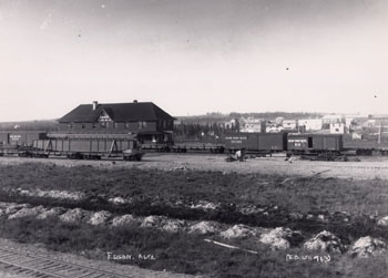
Edson, Alta, incorporated as a village then as a town in 1911, population 8475 (2011c), 8098 (2006c). The Town of Edson is the distribution centre for a mining, timber and oil area 200 km due west of Edmonton. Named for Edson J.
"https://d2ttikhf7xbzbs.cloudfront.net/media/media/2a873a72-a5a8-4819-8605-59b9966ba43d.jpg" // resources/views/front/categories/view.blade.phphttps://d2ttikhf7xbzbs.cloudfront.net/media/media/2a873a72-a5a8-4819-8605-59b9966ba43d.jpg