Article
Province House - Halifax
Province House, Halifax, built between 1811 and 1818 to house Parliament, the courts and the public service of Nova Scotia.
Signing up enhances your TCE experience with the ability to save items to your personal reading list, and access the interactive map.
Create AccountArticle
Province House, Halifax, built between 1811 and 1818 to house Parliament, the courts and the public service of Nova Scotia.
"https://development.thecanadianencyclopedia.ca/images/tce_placeholder.jpg?v=e9dca980c9bdb3aa11e832e7ea94f5d9" // resources/views/front/categories/view.blade.phphttps://development.thecanadianencyclopedia.ca/images/tce_placeholder.jpg?v=e9dca980c9bdb3aa11e832e7ea94f5d9

Article
Province House in Charlottetown is the home of Prince Edward Island's Legislative Assembly.
"https://development.thecanadianencyclopedia.ca/images/tce_placeholder.jpg?v=e9dca980c9bdb3aa11e832e7ea94f5d9" // resources/views/front/categories/view.blade.phphttps://development.thecanadianencyclopedia.ca/images/tce_placeholder.jpg?v=e9dca980c9bdb3aa11e832e7ea94f5d9
Article
In 1841, Britain united the colonies of Upper and Lower Canada into the Province of Canada. This was in response to the violent rebellions of 1837–38. The Durham Report (1839) recommended the guidelines to create the new colony with the Act of Union. The Province of Canada was made up of Canada West (formerly Upper Canada) and Canada East (formerly Lower Canada). The two regions were governed jointly until the Province was dissolved to make way for Confederation in 1867. Canada West then became Ontario and Canada East became Quebec. The Province of Canada was a 26-year experiment in anglophone-francophone political cooperation. During this time, responsible government came to British North America and expanded trade and commerce brought wealth to the region. Leaders such as Sir John A. Macdonald, Sir George-Étienne Cartier and George Brown emerged and Confederation was born. (This is the full-length entry about the Province of Canada. For a plain language summary, please see Province of Canada (Plain Language Summary).)
"https://d2ttikhf7xbzbs.cloudfront.net/media/media/dcae055f-192e-4de7-b004-4a70146eca56.jpg" // resources/views/front/categories/view.blade.phphttps://d2ttikhf7xbzbs.cloudfront.net/media/media/dcae055f-192e-4de7-b004-4a70146eca56.jpg

Article
The Province of Canada existed between 1841 and 1867. The legislation that created the Province of Canada was called the Act of Union. The Province of Canada included parts of what are now Ontario, Quebec and Labrador. Before 1841, the region was made up of two British colonies. They were called Upper Canada and Lower Canada. When Britain created the Province of Canada, it combined these two colonies into one. In the new colony, Upper Canada became known as Canada West. Lower Canada was known as Canada East. The people in Canada West were mostly English. The people in Canada East were mostly French. (This article is a plain-language summary about the Province of Canada. If you are interested in reading about this topic in more depth, please see our full-length entry Province of Canada.)
"https://d2ttikhf7xbzbs.cloudfront.net/media/new_article_images/PoliticsInOntario/Map_Canada_West_East.jpg" // resources/views/front/categories/view.blade.phphttps://d2ttikhf7xbzbs.cloudfront.net/media/new_article_images/PoliticsInOntario/Map_Canada_West_East.jpg

Article
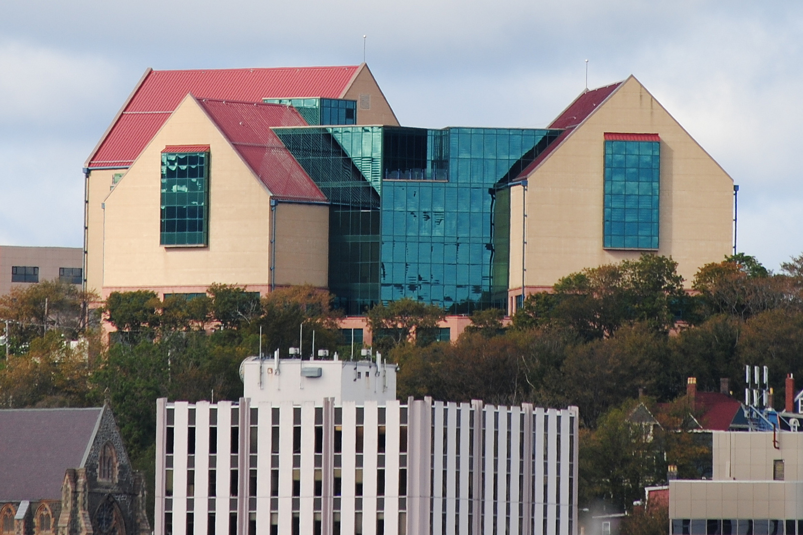
The Rooms is a cultural centre located in St. John’s, Newfoundland, that showcases the history, heritage and art of Newfoundland and Labrador.
"https://d2ttikhf7xbzbs.cloudfront.net/media/media/aa2ca852-f096-4ffa-9886-12f3dd59bb1f.jpg" // resources/views/front/categories/view.blade.phphttps://d2ttikhf7xbzbs.cloudfront.net/media/media/aa2ca852-f096-4ffa-9886-12f3dd59bb1f.jpg
Article
This image of Reesor Lake in Cypress Hills Interprovincial Park depicts mixed spruce, aspen woodland and fescue grassland (photo by Cliff Wallis, courtesy Cottonwood Consultants Ltd.).Typical boreal shield country in northern Ontario (photo by Brian Milne/First Light).PreviousNext Parks, Provincial Provincial parks are areas of land and water, large or small, natural or man-modified, designated by any of the provincial governments for the purposes of nature protection, recreation, TOURISM, historic preservation and education. They range in...
"https://d2ttikhf7xbzbs.cloudfront.net/media/media/ca373d61-2489-44ec-a604-201d64f5116e.jpg" // resources/views/front/categories/view.blade.phphttps://d2ttikhf7xbzbs.cloudfront.net/media/media/ca373d61-2489-44ec-a604-201d64f5116e.jpg

Article
Prud'homme, Saskatchewan, incorporated as a village in 1922, population 167 (2016 census), 172 (2011 census). The village of Prud'homme is located about 45 km northeast of Saskatoon. Prud'homme is the hometown of Jeanne Sauvé, a former cabinet minister in the Pierre Trudeau government, the first woman to hold the position of Speaker of the House of Commons and the first woman to act as Governor General of Canada.
"https://development.thecanadianencyclopedia.ca/images/tce_placeholder.jpg?v=e9dca980c9bdb3aa11e832e7ea94f5d9" // resources/views/front/categories/view.blade.phphttps://development.thecanadianencyclopedia.ca/images/tce_placeholder.jpg?v=e9dca980c9bdb3aa11e832e7ea94f5d9
"https://development.thecanadianencyclopedia.ca/images/tce_placeholder.jpg?v=e9dca980c9bdb3aa11e832e7ea94f5d9" // resources/views/front/categories/view.blade.phphttps://development.thecanadianencyclopedia.ca/images/tce_placeholder.jpg?v=e9dca980c9bdb3aa11e832e7ea94f5d9
Article
Pugwash, NS, incorporated as a village in 1948, population 744 (2011c), 784 (2006c). Pugwash is located 65 km northwest of TRURO, at the mouth of the Pugwash River.
"https://development.thecanadianencyclopedia.ca/images/tce_placeholder.jpg?v=e9dca980c9bdb3aa11e832e7ea94f5d9" // resources/views/front/categories/view.blade.phphttps://development.thecanadianencyclopedia.ca/images/tce_placeholder.jpg?v=e9dca980c9bdb3aa11e832e7ea94f5d9
Article
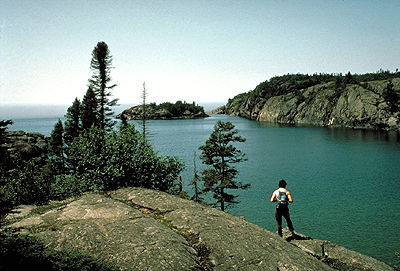
Pukaskwa National Park (designated 1978, 1877.8 km2) is bracketed on the west by the coastline of Lake Superior, an impressive stretch of massive headlands and beaches of golden sand or water-worn cobble. The name is of native origin but its meaning is unclear.
"https://d2ttikhf7xbzbs.cloudfront.net/media/media/8fa1ba40-04c8-4e20-b684-d478d83147ff.jpg" // resources/views/front/categories/view.blade.phphttps://d2ttikhf7xbzbs.cloudfront.net/media/media/8fa1ba40-04c8-4e20-b684-d478d83147ff.jpg
"https://d2ttikhf7xbzbs.cloudfront.net/media/media/9b6a1cce-c95d-4cf8-ab82-694169a097f7.jpg" // resources/views/front/categories/view.blade.phphttps://d2ttikhf7xbzbs.cloudfront.net/media/media/9b6a1cce-c95d-4cf8-ab82-694169a097f7.jpg

Article
Qajartalik (pronounced k-eye-yar-tal-ick, meaning “where there is a kayak” in Inuktitut) is the largest and most well-studied site containing evidence of petroglyphs in the Canadian Arctic. Petroglyphs are a type of rock art made by carving directly into a rock panel. Qajartalik is one of only four known sites in the Canadian Arctic and Greenland with petroglyphs. All these petroglyph sites are located on the northeastern coast of the Ungava Peninsula. Based on the artistic style of the carved images, archaeologists believe the Dorset people, also known as the Tuniit in Inuit oral histories, from the latter third of their cultural period made them. This would mean the petroglyphs are roughly 700 to 1,500 years old. Given the large number of petroglyphs, at least 180, Qajartalik was likely an important site to the Dorset people and is one of the most significant archaeological sites in the Arctic.
"https://d2ttikhf7xbzbs.cloudfront.net/qajartalik/Qajartalik.jpg" // resources/views/front/categories/view.blade.phphttps://d2ttikhf7xbzbs.cloudfront.net/qajartalik/Qajartalik.jpg

Article
Qalipu (pronounced: ha-lee-boo) is a Mi’kmaq First Nation based in Newfoundland and Labrador. The nation was established in 2011 under the Indian Act. According to the federal government, Qalipu has 24,464 registered members in 2021, making it the second-largest First Nation by population in Canada. The nation’s members hail from 67 different communities across Newfoundland. As of 2020, roughly 95 per cent of Qalipu members live in Newfoundland and Labrador; the other 5 per cent live throughout Canada. The Qalipu Mi’kmaq First Nation currently controls no reserve land. (See also Reserves in Newfoundland and Labrador.)
"https://d2ttikhf7xbzbs.cloudfront.net/Marc Humber article pic.jpg" // resources/views/front/categories/view.blade.phphttps://d2ttikhf7xbzbs.cloudfront.net/Marc Humber article pic.jpg

Article
Qausuittuq National Park encompasses 11,000 km2 on northern Bathurst Island and smaller surrounding islands in Nunavut. It also includes the waters of May Inlet and Young Inlet. Pronounced Kow-soo-ee-took, the name of this park translates to “the place where the sun doesn’t rise” in Inuktitut. It is bordered to the south by Polar Bear Pass National Wildlife Area, and together these two zones protect a large, ecologically intact area in the Canadian Arctic Archipelago. Qausuittuq was established on 1 September 2015 as Canada’s 45th national park. It represents the Western High Arctic Natural Region, the 38th natural region of the 39 that constitute Canada’s national parks system.
"https://d2ttikhf7xbzbs.cloudfront.net/media/media/b24f1a0a-425c-40af-87b6-16d3164c5e60.jpg" // resources/views/front/categories/view.blade.phphttps://d2ttikhf7xbzbs.cloudfront.net/media/media/b24f1a0a-425c-40af-87b6-16d3164c5e60.jpg

Article
Quadra Island, BC, 270 km2, is situated at the North end of the Strait of Georgia between Vancouver Island and mainland BC, opposite Campbell River.
"https://development.thecanadianencyclopedia.ca/images/tce_placeholder.jpg?v=e9dca980c9bdb3aa11e832e7ea94f5d9" // resources/views/front/categories/view.blade.phphttps://development.thecanadianencyclopedia.ca/images/tce_placeholder.jpg?v=e9dca980c9bdb3aa11e832e7ea94f5d9